Friday 24 June 2016

Hiking - 2016 PCT - Day 54 to 62

After a relaxing afternoon a few of us headed to the local micro-brew to get loaded... err... up with the extra calories needed for a thru hike! With all those extra calories I needed an extra day in town. Great bacon breakfast then tried to find a steak for lunch. 3 places that serve steak only serve it for dinner. No lunch steaks! Finally hit up KFC for lunch, KFC over here don't have chips! Blasphemy. 

I lazed about the hostel from most of the afternoon with a few other hikers before heading out for dinner (yes steak) and then back to the hostel to get an early sleep for the next day.

Caught the bus back to Independence and then got a fairly quick hitch back to the trail head. Despite my thoughts coming down this pass the up hill wasn't too bad. It also make you feel a little better when you come across day hikers, with hardly any gear, then speed past them. It's good to be back in the wilderness!

image


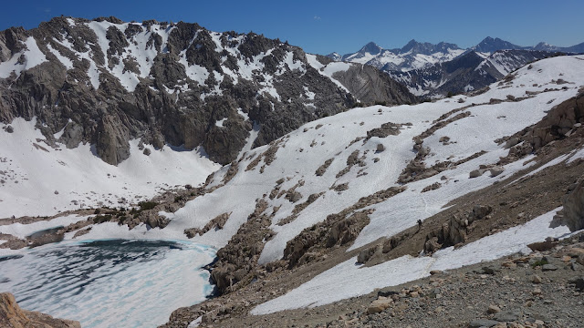
After getting over Kersarge and back down again it was time to head up Glenn Pass. Beautiful alpine lakes on the way up to distract from the climb. Still a bit of snow covering the switch backs so there were some... interesting trails to get around them.

image


Coming down the northern side had even more slow. At a few places this was awesome though as you could glassade (AKA ass slide) down the mountain.

Rae lakes down the bottom were awesome as well. Just as we were reaching them someone was taking a quick dip! Snow melt water at 445pm, no thanks. Finding a camp just a little further on was fairly easy and in the sun it even felt kinda warm. Hope it can stay like that for the night!

Well it didn't stay warm. Wasn't too bad but cold enough in the morning to delay my exit from the comfort of my sleeping bag. A long way down today to the bottom of the valley. Feet got wet on a few creeks but the main river at the end had a cool suspension bridge to keep hikers dry.

image


Then I started the 7 miles of uphill. Lots and lots of uphill. This one, Pinchot Pass, felt harder than all others... even Forrester.  I think it was because of the amount of steps. Seemingly endless at some points. Most of the way we were beside fantastic cascading falls though, so I didn't mind taking a break to look at the view.

image


Finally made it to the top and began heading back down. Snow covered track with footprints going everywhere made me lose the track for a few min. I knew it was near me though and pushed on down the valley until I came across it again. More beautiful alpine lakes made the afternoon pass quickly.

image


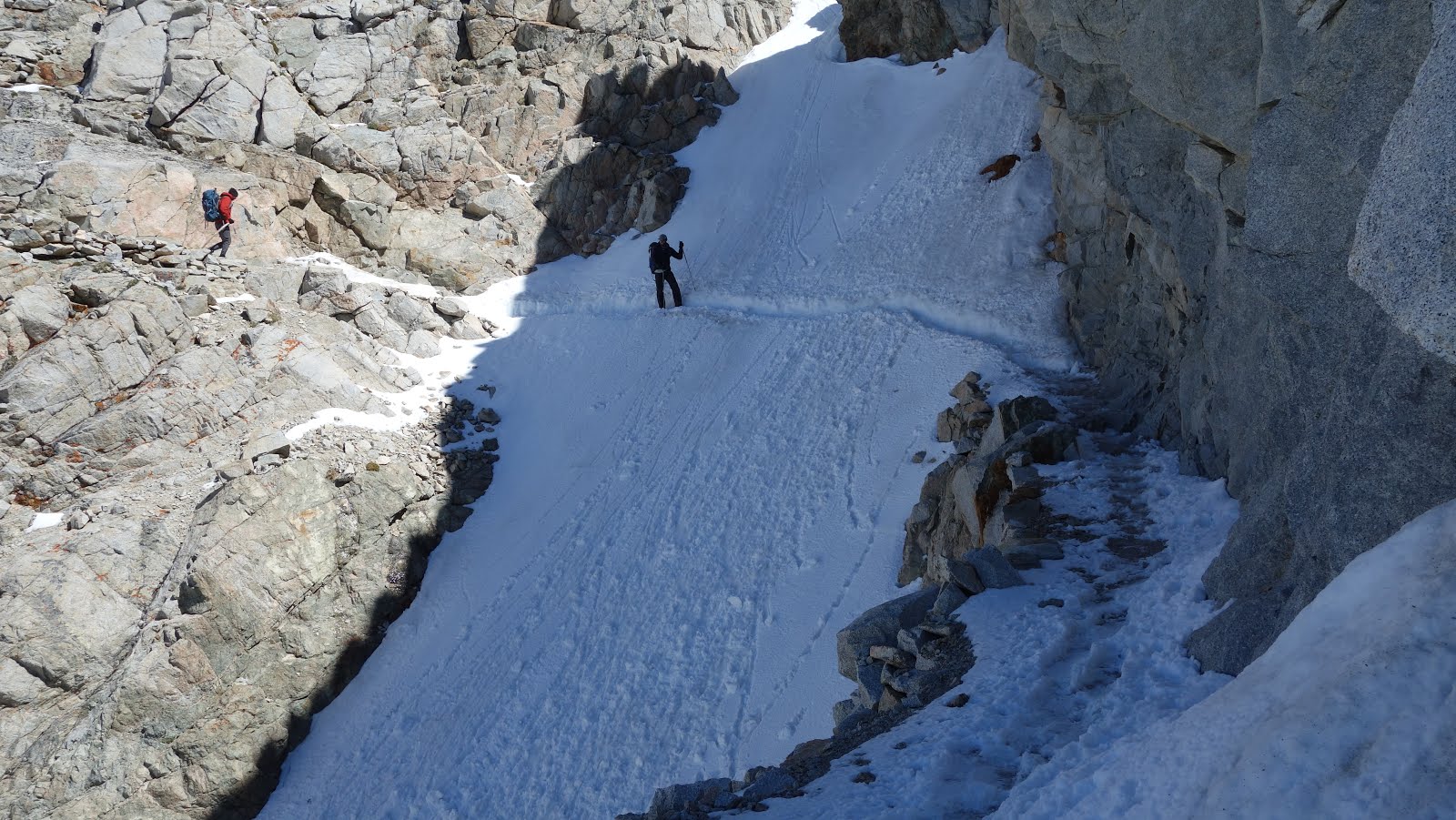
Although covering roughly the same height over a shorter distance the next pass didn't seem as bad. There was a really steep bit at the end made even steeper by some of the switchbacks covered in snow.

Getting down was steep again, but with plenty of snow it meant more sliding! There was 4 slides in total one only 10m long but others cutting through quite a bit of trail.

https://youtu.be/rlpDbJv0lzc

Once over the snow we were walking along a mountain  side for a while and had great views of the valley below. Went down a very steep section before the trail mellowed out and followed the valley floor. Made for great views.

image


Following along a crystal clear creek for miles made me long for a swim. All those thoughts were squashed when I soaked my feet. Yep still snow melt! It did look very beautiful and really inviting though. Made camp just at the end of another gorgeous meadow. Might not have been the best idea thugh,  had to eat dinner in the tent due to all the mozzies!

image


image


Luckily it seemed the evening chill had driven the mozzies into hiding so I was able to have a pleasant breakfast. Luckily too as Muir Pass today was pretty difficult.

This time we were heading up the steeper side so all the good slide spots meant snow ladders to me... It was so steep that some of the track was even blasted out of the mountain side. You could make out the drill holes and where the explosives were placed during construction.

image


The reward up the top was a cool little stone hut and more glorious views. While not a steep descent (meaning no slides) it still proved difficult. The snow was weakened by the sun and there was a snow field almost 4 miles long to cross.

image


Post holing (where one leg falls through the otherwise solid snow) really slowed progress. When one leg is thigh deep in snow and the other is still on the surface it takes some effort getting out. Shoes were already wet due to snow but post holing into a stream was especially invigorating. 

I had also noticed I was getting a bit of a sore back yesterday, which continued today. I thought it was just all the uphill and leaning forward putting more pressure on the shoulder straps. I went to check my straps incase they needed adjusting and discovered the aluminium support had snapped. It's job is to transfer the majority/all of the gear weight onto my hips. First major gear failure :( and 4 days from the nearest town with any kind of decent shops.... bugger.

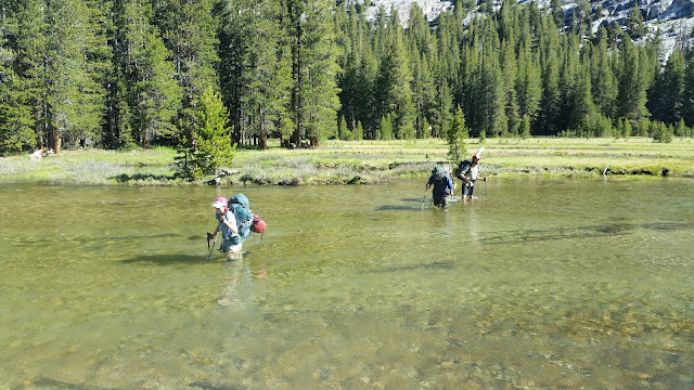
Morning started pretty well with a few intricate creek crossings. One stream had 3 main flows and required you to double back across the middle stream to stay dry. Evolution creek had no way of crossing dry. I took (as did everyone else) the high water alternative... not sure I would have like to see the main crossing, the shallow one was already wast deep. Luckily through the meadow it had a pretty gentle flow, about as strong as Eli creek on Fraser Island. Where we passed close by down streams it was pretty fast rapids.

image


Another steep exit out of a valley for Selden pass. A lot more exposed today too, without the shade of the trees it felt quite hot. The big climb was only because the valley was so low. The pass itself still had its fair share of snow but was just under 11 thousand feet so a lot more than I was expecting! Even had to push on past a few potential campsites as I didn't want to set my tent up on snow.

image


The morning started out pretty resonable. Got away from camp a little earlier as the sun rose in a gap in the mountains and actually managed to hit my tent early! About 2 miles on was the crossing of Bear creek. It was flowing pretty fast and was kind of deep. Andrew (pictured) is 6'3" it was a lot higher on me...

image


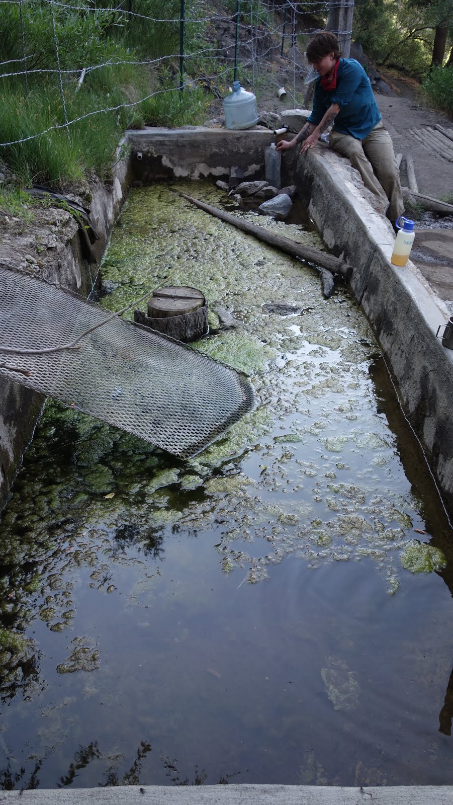
Further down the trail I took a side ridge trail into VVR, a little campsite with a small store, hot food, showers and beer. They have a ferry across the nearby lake that saves 4 miles but only runs twice a day. On the trail I came upon a group of Forest Rangers that stopped me and asked for my permit and to see my Bear can. They were friendly but it felt a lot more formal than my previous meetings with Rangers.

Shower was amazing after 6 days in the woods with only cold water. Hot food went really well too. Breakfast burrito in the morning before catching the 'ferry' back to the trail head. By ferry I mean fishing tinny, our ski boat could comfortably fit more people... but they squeezed in 5 hikers+gear and got us safely across.

image


Of course the trail started by imediatly heading up. Silver pass took a long time to climb but didn't feel very difficult. Trail up the top was covered in snow, however I'm kinda glad that I got to do it on a elativly high snow year. So much water flowing down amazing falls almost every turn.

image


Camped near a great lake but the wind coming off was a bit cool. The next day was only a short 13 mile hike without too much climb but the day felt like it went so slow. Finally made it to Mammoth ski resort, heaps of downhill hike runs going about was cool to watch for a bit.

Caught the free shuttle down to Mammoth Lakes to arrive at a huge chateau hired by a fellow Hiker. Beds for 10 people and about $15 cheaper than the hostel. Taking a zero here to get a new pack sorted and get refreshed before hitting Yosemite!

image

Thursday 16 June 2016

Hiking - 2106 PCT - Day 46 to 53

Enjoyed a very large pancake breakfast in the morning and as the power is only on when the generators are going had to hang around a while to recharge devices. By the time that was done it was close enough to stay for lunch and then wait for the cool of the afternoon before making a start.

KM was a good place to hang around with card games and lots of other hikers to share stories with. Everyone busy for a while sorting out their resupply packages and gear for the next few days, trying (and falling short) to cram all their food into their Bear Canisters.


While the afternoon still wasn't quite cool a few of us set off around 230. We stopped by a good creek where I took the chance to soak my feet again and others jumped in. I'm not a fan of swimming before a long hike, too much... friction.

We aimed pretty high for a great site we were told about. With the late start, lots of elevation gain and the break for a swim we ended up hiking well into the night. It was great to see the sunset on an awesome cloud formation, but with ~2 hrs hiking by head torch to arrive at camp just before 10 I wonder how much other scenery we passed. Plenty more to see out here though!


Woke up to frost on my sleeping bag and sparrow poop on my bag. Still was a pretty good spot on the sandy shore of a river. The day started with a climb up to a pass almost as high as San Jacinto. The saddle between 2 mountains was as high as the highest mountain I have ever climbed...

It wasn't as scenic as San Jacinto because, thankfully, there wasn't any fresh snow fall. I did offer some amazing views and was still pretty special. Nice big pine trees also kept me in the shade all the way down.


Stopped for water at a fast flowing stream, Death Canyon, and came across an old nemesis, the mosquito. I was thinking it would have been a good camping spot. Lots of nice flat areas, water on hand to save carrying dinner/night water. However when one mozzie was biting me through my shirt I knew I had to move on. Pushed uphill a few more miles to find a suitable spot.

Despite a few more climbs the next morning felt really good. I spent most of the day walking above 10,000 ft and while I can still feel the effects of the altitude it's not as bad as other days. The trees are also getting bigger but with the foot traffic in front of me every time I've come across a fallen one there has been a track cut around it.


It's really scenic here but it's strange as I haven't really seen any one view/location that had had me stop and think "wow that's awesome" but every time I stop to catch my breath, rest my feet, collect water or water a tree I look around and think how beautiful it is. That was until I reached Chicken Lake. Too cold to swim though...


After the lake it seemed like I was stopping every 0.5 miles to take in the scenery and take a picture. Views of mountains through amazing trees.


Just after I set up camp some friends walked past with news from people just out of Lone Pine. Possible storm on Mt Whitney tomorrow night... which I had planned to summit the morning after... Might make the climb up a little interesting with a fresh coating of snow.

More amazing views throughout the day. Meadows, Mountains and brilliant pine trees. I also got to see quite a few Marmot which apparently aren't that rare... was also deer in the fields and lots of other critters.


The day started out really easy with the first 1/2 mostly down hill. At the bottom of a valley I came across my first alpine stream. Some people were walking through, others removing shoes or putting on crocs etc. I ventured a little bit up stream to find a large log. Little high off the water but I didn't plan to fall.


Later in the day there were more streams some easier to hop across than others. One stream I carefully went over some rocks and a small log. Didn't seem too bad. Another hiker saw me and tried to follow but bailed when he lost his balance on the first rock. Luckily didn't fall into the snow melt water, but then had to walk though shin deep anyway... I'm not looking forward to the places I can't find a suitable crossing.

Got to the ranger station to get the low down on he weather. "You can't tell in the mountains... but more like today probably" Awesome... chance of a late storm and probably overcast. They might get fresh snow but probably not much. Clouds closed in by 630 am, so unless I want to start at 2am I might not get the best views.

Went to quickly set up the tent before the impending rain... but it turned out to be tiny tiny hail instead. Still annoying and the bits that got in my tent quickly melted to water anyway. Everything else bounced off and managed to stay dry.

With the impending bad weather I took my first trail zero day. I could think of worse places to be forced to stop... The day went by pretty slowly,  had to hide in my tent a few times to avoid the snow.


Awoke to a dark but clear sky. Wanted an early start. The first river crossing just outside of came was sketchy as the logs were icy. Managed to stay dry and start the ascent to the summit. It was a pretty hard hike but awesome views the whole way up. All the way there were only 2 small bits that gave me a bit of pause.  Snow sliding away under foot with nothing to grab and a long way to fall.


Also had to make sure that it was indeed the tallest mountain in the continental USA, sitting pretty at 14,505 ft. You can take the man away from Surveying but not Surveying away from the man!


The trip back down was much quicker. Taking it slow for the afore mentioned sections but otherwise booking it down. Much easier to hike fast when 80% of your gear can be left at camp. I got back around 2pm and packed down camp to push on just a little bit further to make sure I could start the Forrester Pass climb, the highest point on the PCT as Whitney is a side trail, fresh in the morning.

I had been going really well finding places to skip across creeks but this afternoon didn't go as smoothly. It was partially because I wanted to move a bit faster and partially because my shoes were already mostly wet due to snow. There were 4 big creeks that I ended up just walking through, socks and all. I think I might need either crossing shoes like crocs or dry camp shoes because standing around camp in cold wet shoes wasn't ideal.


Wasn't in a rush in the morning after yesterday's climb but knew I had another big day. I had to head over Forrester Pass before the snow got slushy. Despite its dire reputation I actually found it fairly reasonable. Climb was tough with the full pack but over fairly quickly. The snow chute was a little intimidating at first sight but only a very short segment.


Made it down the other side and with the snow melt most of the path was already a mini-stream. There were some snow banks within the switchbacks that hikers create snow slippery slides which made the trip down a lot faster!


With the exception of the climb in the morning most of the rest of he day was downhill... until I reached the next pass. Kersarge Pass. The plan was to camp in the valley and make the trip over, out to the town of Independence, the following day. I arrived a little earlier than expected and decided to push on... a decision I regretted about 5 min into the climb...

Once I reached the top though it felt great. I was rewarded with awesome views and a feeling of achievement. Plus I knew I was closer to a hot shower! Got to the trail head about 1815 and by 1850 had a ride down to town. After getting sorted in my room having a shower and putting the laundry it was too late to head out for dinner so I had a Hiker meal in my room. Plenty of chance for town food tomorrow.

The 40 mile drive to Bishop ended up easier than expected, the owner of the Inn needed to head to the bigger town and offered me a lift! Checked into the hostel and saw some old friends before getting down to chores.

My bounce bucket is here which means backing up photos, more Milo and sending off a package or 2. I also needed some grocery shopping and to seek out new tips for my trekking poles. I've managed to grind down the old tips from about 100 mm in length to 20 mm.

After the chores I was finally able to settle down with a beer and enjoy the backdrop of the mountains.


Tuesday 14 June 2016

Hiking - 2016 PCT - Day 36 to 45

Went into town for the last chance at a real meal. On the way back Redhawk decided to get in some extra training by carrying She Bear. I think he lasted about 50 meters. Apparently she wiggled... In the morning I got a lift back to the trail from a local Trail Angel, Dog Bite. This guy runs hikers around town most of the season and will pretty much pick you up and drop you off anywhere. With 8 days of food and plenty of water in my pack it was feeling pretty heavy.

The day started off with a pretty decent climb and as I was leaving town it was already pretty warm. It was glorious. So much better than the cold winds out from Wrightwood. I think I'm the only one appreciating it though...

Came across a section of dirt road walk trail that reminded me a lot of Ormeau. Lots of dust rocks and step ups. There was also the tell tail signs of slippage with rubber left behind on the rocks. I spent about 3 hours picking lines I would take in the Jeep. It was pretty clear what lines the hikers took though.


Made it to Golden Oaks springs, which was little more than a trickle. With over a dozen hikers there it took a long time to collect water. By the time I was done I figured I may as well camp the night. There was a nice little spot about 50m away up hill.

Started off with a nice downhill stretch in the morning to get into it before once again heading up hill. Near the top reached a great pine forest providing excellent shade making he hike fairly cool.


Made it to my planned stop, another spring, with time to spare and decided to push on. Made it my longest day yet, 25.9 miles. I certainly felt it by the end and it was actually dark by the time I went to bed for once.

The next stretch was a 42 mile stretch without any natural water sources. I filled up to my full capacity, 6.5 lt, with the knowledge that there should be a few well maintained water caches along the way. Before today I thought that 8 days of food was heavy...

Planned an early start with a 4 am alarm... but still barely made it out of camp by 6am. Only 7 miles out of camp I found my first water cache. Still had plenty on me but drank a bit before I got moving again. Well and truly in the desert section at the moment.


Passed a few people that pulled up stumps at 10am because it was too hot but I kept going until about noon. By 230pm I was bored and ready to get moving again. 330 I passed some friends that told me I was mad hiking in "this heat" ... it wasn't even 30°c today and only like 12% humidity!

Made it to the next likely water cache to not only find heaps of water but also an esky full of goodies. Chocolate, protein bars, Nutella and lollies. Great find. Was late in the day so it was also topped off with an amazing sunset.


Another early - ish morning start to get up a very steep and tall hill. Almost full of water again so another heavy pack. Luckily I was heading up the western side of the mountain so I was in the shade the entire way.

It was really good walking along ridges for a while enjoying the views. When I had stopped to take a break a SOBO (south bound) Hiker brought by some bad news. There was currently a bushfire raging just north of Walker Pass. Currently closing and potentially threatening the trail.

Made it to the Walker Pass campgrounds mid afternoon to see a few other hikers. There was also a guy from the fire service giving out information. Fire was mostly contained already and all was going well with the fight. About 2 hrs later he came back with a massive smile on his face happy to bring the news that it's a 99% chance to be reopened 6pm tomorrow.

It was already late in the day so I decided to bed down there for the night. Turns out it was a good call because I woke to the most amazing smell, bacon! A couple of trail angels were cooking up breakfast. They also had a big box of softdrink and beer. Being 7am in the morning I of course opted for the cold beer with a Gatorade chaser.


Not wanting to spend an entire day in the fairly desolate Walker Pass camp I decided to make my way into Lake Isabella. Met up again with T-Bird who was organising a 'cookout' (BBQ) so I bought some steak to throw on and potato salad to share.


I had planned for an early morning but by the time I rolled out of the comfy bed, had another shower and finished a fruit breakfast I was looking for a hitch after the time I would normally be hiking out of camp. Took a while to flag a ride and the first to stop was only going to Weldon,  about 1/2 way. As it was better than nothing I took it. At Weldon it was another long wait until a SUV full of fellow hikers finally stopped to take me the rest of the way.

The first climb was on the eastern side if the mountain and due to the late start was already quite warm. Bit of a breeze kept it reasonable but even I sought out the shade for breaks.


Made it to the top of a ridge for a great place to camp. Thought I would start the day down hill but the PCT took me up along a ridge and over a mountain before heading back down. Went past the burn area that temporarily closed the trail. It was at a camp site 0.2 East of the trail but luckily the wind was blowing away and it didn't touch the trail.


A few miles later there was another section that got hit by fire a few years ago. There was no shade for a 7 mile stretch, it wasn't that great. I eventually made it to a stream with a very slow flow. It was enough to get some water and a good place to camp for the night.

The next day it was a gentle 9.6 miles into Kennedy Meadows. This is the doorstep to the Sierra Mountains, said to be the most scenic, fun and difficult section of the entire PCT.

KM is a town with 1 bar/restaurant and 1 servo/store. There was about 70-80 hikers all hanging around collecting boxes and enjoying civilisation/power for the last time in many days. No phone signal and the wifi is so slow that even sending a 2 sentence email took a few minutes. That's why you're getting this post a little late.


Behind the Blogger