
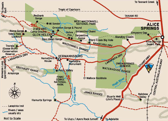
The Trail runs East/West, with one end at an old Telegraph Station just north of Alice Springs and stretching almost 231km (by foot) out along the West MacDonnell Ranges finishing atop Mt Sonder.
The others were heading to Uluru / Ayers Rock first and then winding their way back to Alice via Kings Canyon and West MacDonnell National Park. So I picked a time to fly out to Alice when they should be in the middle of their trip back, camped somewhere along the way.
To make my trip easier, and save me having to do a bunch of shopping when I landed in Alice Springs, I was able to load up my food drops into plastic tubs and send them on their way in the back of Dads (custom built) camper trailer. Standard affair for hiking food. Dehydrated meals, Muesli Bars, Pasta sides, some dried fruit and Skittles. Lots and lots of skittles.

The day finally came for my flight out with a lot of my gear already in transit my pack was really light. If only it could be this light all the time! You can check out my loadout here. It's definitely not the lightest kit out there but it's fairly light and I feel it's a good balance between comfort and weight.
Standard check in affair at the Brisbane domestic airport and a nice relaxing beer in the departure lounge before hopping on my plane. Fairly short flight out and a quick taxi into town. Went to the hostel to check in, then popped over straight away to the National Parks office to pick up the food drop key and then off to the 'Lone Dingo' camping store to pick up a spare gas can and woolies for final food supplies.
Like a lot of my plans the hike deviated day 0. Jeremy had come into Alice for a restock and refuel and shot me a message. So 2 hours after checking into the hostel I checked out... shortest guest ever? He took me out to Ellery Creek to a surprised Chris and Rod who were expecting to drive into pick me up the next morning. After reading a book to Kristina and Emma and a little communal fire time I was ready for bed. Should be a nice cool night.
Day 1 - 15.8km
Wasn't wrong with it dropping 3°c inside my tent over night. Would have been even colder in the wind... As there was no longer the need to travel into Alice the morning was a lot more relaxed than planned. I sorted out the last little additions for my food boxes and was able to drop the first one right at camp.
The next two also went in pretty easy. Staff at Standley seemed really friendly and the kiosk at Ormiston proved very useful for their sausage rolls! From there is was a short drive to Redbank Gorge to officially start the hike.
Kristie and Jeremy came out with the girls to see me off as well as do the walk into the gorge itself. After a few photos we parted ways and I begun setting up base camp.

A few hikers camped in the river bed but I picked a spot just up the bank. Camp was quickly set and it was time for me to hit up Mt Sonder. Plenty of trail markers dotting the well worn trail kept me on the right track. If it wsnt for the chilling cutting wind it would have been a nice temp too. It was a little cold to hike, but with the uphill slog far to sweaty to don a jacket. Still the entire way up the view got better and better until I was at the top and could take stock of the adventure ahead.

Back at camp I spotted a feral cat licking at drips from the water tank. Second one already, the first on the drive out. Both pretty big. I wandered down to some other hikers, they had just finished. It was nice to get some insight about what's ahead and the good spots. Soon after dinner it was too cold to stay out so I sought shelter in my tent and fell asleep soon after.
Day 2 - 18.7km
Slow rise again due to the cold morning though at 5° it was warmer than yesterday. I half packed before breakfast and then went for the short wal into Redbank Gorge. The trail along the bank soon went into the river bed with sand underfoot. The closer you got to the gorge the more rocky it became and ended in a beautiful canyon. Water was absolutely freezing. Tinknell would have probably swam though...

Back to camp to finish packing, said goodbye to the guys I shared dinner with, their bus was due to take them back at 11. Pretty flat trail for most of the day. With the wind still blowing I was hiking in my long sleeve Merino top at a fairly pleasant temp. Felt like leaving the gloves on though.
Stopped at Rocky bar gap for lunch and to get some water. Not long to camp from here so I stayed for almost 2 hours just enjoying the quiet. Wind was still cold but at least it kept most of the flies away.
Made it to camp just after 2 and picked out one of the pre cleared spots. Plenty to choose from. Not a bad place to wait for a sunset. Had a lot of free time so I explored the top of the hill and extended my rock wall wind break a little. The sun fell just by Mt Sonder and lit the sky with some impressive colours.


Day 3 - 18.1km
I new it was going to be colder spending the night at the top of the hill but I wasn't expecting -4°c!! Still I don't think I felt it as bad as the first night at Ellery and it was worth it for the view. Mt Sonder was shrouded in cloud this morning, bit of bad luck for anyone that made the climb for sunrise.
The day started with a pretty steep downhill slog on loose shale rock, made for slight slower going but provided great views to the south the whole way down.

When I got to the bottom I reached a section that had been scarred by fire but at almost every burnt out tree were fresh green sprouts springing back to life. There were also a heap of creek crossings including the majestic Finke River. It was a little touch and go there, but I managed to keep my shoes dry.


The side track into Glen Helen was pretty nice, some great rock formations and some of the water holes on the Finke actually had water! Two Mile camp spot seemed like a good place to stay which I spied from across the pool of water. Glen Helen itself had some awesome burgers and the chips and beer went down pretty smoothly too.


It was time to hit the trail again only 4.5k to camp for tonight. Making it there by 1330... I think I'll need to do some longer days. The shelter setup was good though, solar to charge batteries/phone, water and a drop toilet. About an hour later a west bound couple hiked in, good to have some company for the night.

Day 4 - 17.4km
Pack up was a little easier from the shelter with no tent and seats to use so I was on my way fairly easily. This next section definitely had worse fire scars than yesterday. Without any significant vegetation wind seemed even worse as well. It would have been pushing 40 knots or more as a head wind adding to the strain of hiking. However it was a little warmer than the previous days.

After about 5k I passed the first hiker going the other way. She was a little surprised when I told her how far it was to the shelter and that I had only been hiking an hour. She had left Ormiston (~4k) over 1.5 hours ago. I got a similar reaction from her friends that I passed soon after. Before 10 I was at the Gorge and grabbed my first drop box to resupply.
After a nice sit in the sun Rod, Chris, Kristie, Jeremy and the girls showed up so we could hike the pound loop together. Dad was very happy to have my overflow food, skittles and pringles. I think the girls were too. The Pound walk is a really good little loop definitely worth doing if you're out this way. Kristie and Jeremy did an impressive job of carrying the girls (who alone weigh more than my entire pack) in their travel packs. Towards the end I gave Kristie a little break by taking Emma for awhile.


Nice hot showers here and a chance to wash some clothes, they definitely didn't dry as fast as advertised with my shirt still wet before I went to bed. At camp we shared some good stories about various tracks we've done and future planned ones. Luckily Jeremy gave me 2 beers so I was at least able to share one with them. In return I was offered an amazing pudding snack and even some scotch! Good trade.
Sadly also in the coach area, not far from us, was a school group. A very loud school group. Kinda wished their leaders took them on a longer hike today because they were still hollering as I was trying to sleep, continuing well past 'hiker midnight' (9pm)
Day 5 - 28.3km
Quick pack in the morning and said my goodbyes to the Melbourne guys before setting off for a little longer of a day. Wasn't far before a 450m elevation gain, biggest since Sonder. There is an awesome spot that would be perfect for the night about 10k out of Ormiston. Naturally sheltered from the wind and 360 views.

A little further to the summit with a little '3G is here' sign but I was on a roll so kept moving. Heading down the other side was really steep. SE Ridge on Mt Barney steep. It wasn't long before Waterfall Gorge and lunch. This is where the Melbourne crew were aiming for tonight. With a bit further for me I pushed on.
Passed a few west bounds, including one lady that had spent the night with the family at Ellery and a pair that were cooking lunch right in the middle of trail. Plenty of spikes grass off trail though so it was a good as place as any.
I thought I was making great time until I ran into a gully with steep walls and huge boulders to climb over slowing me down. Pretty though. There were also a few wild flowers near trail worth stopping to appreciate.


Got to the shelter with two other hikers setting up and a lot of day hikers finishing a leg for the day. Excitedly planning the following days activities, lamenting the one kilometre they still had to go to the cars and in awe of my 28+ k day. I spared them (but not you, dear readers) the details of the butt chafing I started to experience at the ~22k mark....
Shelters are easily big enough for 8 hikers with room to spare. Even 12, 6 per side, would be fine. You'd definitely squeeze in a lot more if you were friends or it was a poor weather night. Still with me at one end the other pair each set up their tents less than 10m away from the shelter. I guess despite the Ormiston shower I probably smell.... in all fairness though, they've done 8 sections so they would too.

Day 6 - 27.9km
Another good start in the morning where the ks fell fast. Wasn't too long before I was at the base of the next big hill. Lots of steps on this climb really making the legs work hard. Wind still hadn't let up either but at least with some switch backs it was a tail wind rather than just a head wind. Counts point was an amazing place to stop for a smoko break.


On my way down from the point I met another group of 4 that had shared a fire with the family at Ellery. They were all on the lookout for a orange puffy, but it's a little hard to see packed away. Not many East-bounders though so they took a guess it was me. Lots of people are hiking in their jackets or at least wind blazers. I've set off most mornings with my thermal top on but figure being a little cold on the move is good motivation.
I thought the steps on the way up were bad but down was worse. Little loose rocks/sand making every step a calculated move. Wouldn't want to do this bit with a bung knee. After I was down it was a short jaunt into Serpentine Gorge which was a beautiful spot to stop for lunch.

For a 'mostly flattish' section the second half of the day certainly had a lot of up and down. Pretty significant rocks to navigate past too. At the top of one such hill was the reward of an old Trig Point. Though might hold more significance to me compared to most other hikers.


Made it to Ellery Creek just before 4. A day ahead of schedule so far. As always I've slightly over budgeted for food so I was able to leave a few things in the box and label it 'Free Food' so hopefully some other hikers can get some use out of it. There was definitely plenty of food in the storage room though! Might be a busy trail ahead....

Ellery Creek is probably the best waterhole so far as well. Great place for the half way mark. Far to cold for a swim but I managed to hold my feet in there for at least a good 15 seconds...


Back at camp for dinner and some really friendly campers got a fire going and invited me to share. They didn't have to ask twice! They even offered to take my rubbish after a totally innocent "Did you guys notice any bins on the way in?" Their Trail Magic didn't stop there but I had to decline the 3rd beer as I had a 30k day to look forward to tomorrow.
Countdown to Alice begins!

Hi Scott
ReplyDeleteThis walk has been on my bucket list for many years but after reading your great blog I've decided my knees probably aren't up to it so I'll enjoy the trip vicariously, impressive walking up to 30K a day
safe travels
Noel S
One of the guys in a guided group was 72 (Seventy-two!) and they were getting through it. Even if it took them all day.
DeleteMany of the sections (with 4wd support) can be done as day hikes. A few are 1 night treks but most (all bar one) have water so you don't even need to carry that.
A lot of people were doing it as an 18-20 day hike, so didn't need to push as hard as I did. They also had much heavier packs than mine (some were probably 3x the weight of my pack...)
On the PCT I clocked a 60k day, 12.5 hours of hiking... was pretty wrecked after it. Even with the all day every day training for 3 months leading up to it.