Saturday, 15 August 2020

Hiking - 2020 08 - K'Gari (Fraser Island) Great Walk.

Day 1: Happy Valley > Valley of the Giants - 20.8km  
Day 2: Valley > Wabby (+Side trips) - 27.9km  
Day 3: Wabby > Central Station - 19.1km  
Day 4: Central > Jabiru Swamp Camp - 31.3km  
Day 5: Jabiru > Inskip Car park - 17.5km  

With the others already gone and the curry pie successfully consumed it was time to head off and find the start of the Great Walk. Only a few hundred meters up the road was the official terminus... and a lot of signs warning about Dingos... (You can read about where the Pie came from at the end of my (K'Gari) Fraser Island Diving post)

Considering that K'Gari is a sand island the track was relatively solid. A few sections gave way under foot but mostly it was fine. Lots of fallen trees to clamber over, or around, with the softer sections did make for slower going. It wasn't long though before I made the first camp 6.7km in... I was skipping this one. Nice lake though.

The next bit was more forested which helped with the path surface. Still plenty of trees down to make things interesting. Very large pines that seemed to reach into the clouds. My trekking pole is 1.15m for reference.

Just before 5pm I made it to where I was camping. 20.8km, not a bad afternoon. One other camper here so after i was setup I joined him for dinner. He's from Melbourne (seem to be meeting a lot of them lately...) but started an Australia tour back in Jan and has been in QLD since March.   

As he is heading north I was able to glean some info about the trail (and the 0 Dingos he has seen.) We also shared tails of other adventures which is always nice to take a few notes from. He was heading west soon so I put him onto Carnarvon as a must see. Mozzies were pretty aggressive, so we soon retired to our tents. I would have barely made 7pm before falling asleep.

Easy pack in the morning and I said my goodbyes before heading out. It was just 400m to the first side trail of today. Up to a Giant Tallowwood, over 1000 years old and 11.5m in circumference!

It wasn't much further for another (7.2km return) side trial to another big tree. Still very impressive but a lot of extra kms for one tree... A lot of others must have had the same thought as the trail is less travelled and in softer ground. Something I should note for this trail; If you're a trekking pole user use the blunt stop ends. The spikes on my poles dig into the sand too much making them less useful.  

Back to the main trail and just over the 1/2 way point for today was another side trail to Badjala Sand blow. I stopped here for lunch to enjoy the view. What was meant to be a relaxing hour turned into a 45min game of whack-a-mole with Mozzies. I lamented the wind the last few days as it was horrible for diving... but I sure could have used a breeze to keep those blood suckers at bay.  Still, a good view, even if it was an effort to climb the edge of the blow to see it.  


Just as I was hearing up to leave I noticed a tick crawling up my leg. Good to get them before they dig in. There was another couple arriving too, with day packs. They had been dropped off at 'M9' road crossing and were aiming near where I broke camp. K'Gari GW seems to fall victim to a few of the other QLD Great Walls in that there's no place on trail that can't be traversed as a day hike. Takes away some of that remoteness feeling.  

I got to Lake Wabby by 215 and found a group just leaving (towards the beach track) so I had it all to myself. Pretty rare for Wabby. I didn't stay too long though deciding continue on for camp.


After setting up and sitting around camp I questioned my decision to move on from the lake side... I was starting to get sore feet, so glad to be off them, but there were less mozzies by the lake... definitely a better view too.  

One thing about camp though, and most of the trail actually, was the abundance of Midyim bushes. Haven't noticed much in the way of berries (wrong time I think) but in the right season they would provide a great little fresh snack on trail.    

With so much time at camp I took out the map and started looking at my plan. 29.9km today... and if I combine two 'short' days I could do a 32km day and finish a day early... 

2k wouldn't be too much longer, hardly noticeable, and it should be flatter trail too as it follows along lake edges for quite a bit. This would also have the added bonus of less time swatting Mozzies... and even with important blog writing time, 3 hours to kill before sunset solo in camp is a really long time.   

Luckily a pair of hikers showed up at 515 so I had someone to share dinner, and the mosquitoes, with. With my new plan of action I also had some spare Tim-Tams which were good to share as dessert. After here and some time at the Whitsundays these guys plan to do the Larapinta, so it was nice reliving it through their plan.

Had a slow pack in the morning and left camp around 750am. Not a long day today, 18.6 in total. It was 12km to Lake McKenzie where I was due at 1030am to meet the folks, Kristie and Jeremy to get the rest of my food and have a bit of a play with the nieces. Lots of uphill from camp so I was slower than expected.  

One other Nobo hiker who actually came from Hook Point (as opposed to Kingfisher like the rest) so he was able to give me some trail conditions for the remainder of the trek. It wasn't too long before Lake McKenzie came into view which its beautiful white sand beach.

Another 750m on and I was at the car park. Spotted dads Triton pretty quickly (unique roof rack and not many other Tritons on the island) but couldn't see Jeremy's Cruiser. Started to head down to the lake to find Kristie heading up to get changed into togs. She gave me the bad news that they has some mechanical issues with the Cruiser, sounds like blown CV joints :( 

She and the girls hopped in the Triton for the day while he stayed back and tried to get some work done. Kingfisher Bay is better than most office cubicles I guess...  

Down at the lake the girls were enjoying a (very cold) swim. I settled for getting my shins wet. The soft sand (which I'm told is a great way to exfoliate) does wonders for sore hikers feet. 

When it was too cold to keep swimming we went up to the Dingo proof fence for some lunch. Mum had brought some really nice fresh Pineapple. Fresh fruit on trail is amazing. I also had a ham and tomato sandwich and some Cadbury chocolate. I eat well on hikes! A Monitor Lizard hung about for a while too, hoping for a feed.  


After lunch the girls had warmed up and were keen for another swim. I decided to press on. Collected my things, said goodbye again and set off on the short 6.6km to camp for the night. About 4km in I was at Basin Lake and decided that I had plenty of sun left so I might as well take another break.  

The next 2.6k fell pretty quickly and I was soon on the boardwalk at central station. A bus group was coming the opposite way (there's a 900m loop) and had a few questions and comments but it wasn't long before I was at the Walkers Camp. 

It seems that most hikers skip this one (makes sense with McKenzie not far away) as there was branches and leaf litter on all the sites. The others so far had been swept fairly clean, as far as hiker camps go. However I was happy to be here for the hot showers. 

My excitement was short lived. I got ready and dropped 2x $2 coins in only to discover the stall I had chosen had a broken head. A single stream of hot water shot out like a jet, about an inch above my head... Still, I made do using a hand to direct water and got semi clean. Luckily I had a 3rd coin so after the hot water ran out I switched stalls and had a good, albeit short, shower. 


While getting ready for bed I was found by a leech. Another reason to pass on this camp :o No other walkers here though I am close to a regular camp site so I could hear all the car campers getting back from the days driving/settling in for the night/cooking dinner. It was barely past 6 before I retired to my tent. 

In the morning I discovered that a mouse had got into the "Dingo proof" cage and set upon my food bag. Luckily it only got into the milo/powdered milk mix and mustn't have enjoyed it. Leaving the rest alone. At the other camps they had sheet metal boxes which are rodent proof as well. Still, I otherwise would have had it in my tent and likely have a mouse sized hole in that too!


After breakfast was the task of getting up and out of the valley. They're only small hills here but I still feel them. Luckily half way up I was given a good reason to stop, a coastal carpet python sunning itself in the morning light. I may have stopped for some flowers too... 


The morning fell pretty quickly making it to the next camp site, lake Benaroon, for smoko. Only a short break before continuing on to Boomanjin for a slightly longer break, finding a trekking pole someone had forgotten just prior to arriving. The last 2km before here was along the sandy shore of the lake. Some was compacted and easy to walk on but a lot was loose. With full exposure to the sun I was glad for the break.  


Pushing on further to Dilli Village I arrived just after 1pm. And thus officially ended the Great! Walk.


I was kinda hanging out for a soft drink, figured they would have a kiosk with a few things but it was all fenced off with "NO PUBLIC ACCESS" signs... Would have likely been ok but it didn't seem welcoming... so I just snuck in a beach access gate to fill a water bottle and continued on. About 600m down the Jabiru Swamp trail was a nice grassy spot on the shade to pull up for lunch.

Glad I'm doing this bit in the afternoon. Makes it nice and shaded. The Jabiru Swamp trail isn't so much a trail, but a seldom used vehicle track. While some of it was ok a lot was loose sand as you'd expect and also a narrower path to thread (the width of a tyre.) 

After about 4km it did improve, there was a side road where most 4wd must come from/head off. The swamp itself is just that, a swamp. Surprisingly few mozzies though. Little bit of a breeze might be keeping them at bay.  


There was only 3 platforms at camp (at least a dozen at the others on the official walk) and no toilet or water tank. Luckily I knew about the water and came prepared, collected from a stream that crossed the road. Good thing I always bring a trowel and spare TP too!  Discovered tick #2 before dinner.

The next 15km of the swamp trail were as uneventful as the first 10. Swamp and more swamp. At least there was a Blue Tounge to say hello too. No streams south of camp; So carry all your water from the barge, collect from the swamp or walk at least a k past camp. 


Just over 15k and I was onto the beach. A long line of 4wd waiting to depart the island, a few of them asking questions as I walked to the head of the queue. Some Dolphins swam by as I was waiting, then it was on to the barge and almost home free.  


The line to get to the ferry to come over was longer than I had ever seen it. All the way back to the bitumen road! Some nights in solo camps I think how nice it would be to have company, but then I see somewhere like Inskip on a long weekend, 2000 strong with campers. Loud music and people yelling and suddenly those quiet solo sites don't seem so bad.  

A quick pit stop at Rainbow for a pie and a drink before starting the drive home. Had an amazing run down the Bruce. Completely accident free! A spot of rain near the Gateway exit saw things slow, but only a fraction and it wasn't long before I could start the exciting task of cleaning sand off gear...  

Found another 2 small ticks, bringing the total to 4, nestled in when I finally got cleaned up. Just started spitting here, so a good excuse to leave the rest of the gear cleaning until tomorrow!

Wednesday, 1 July 2020

Hiking - 2019 06 - Larapinta Trail (part 1)

It was time again for another decent hike so when I heard that Kristie and Jeremy were planning a trip to the Red Centre of Australia my ears perked up. The Larapinta Trail had been on my peripheral for a while but I was waiting for an opportunity to do it. As a predominantly solo hiker there are a few options ranging from getting dropped off (for ~$300+) or a fully supported and catered package (up to 5 grand!) Neither really seemed all too appealing to me but luckily my Parents were going to head out for a holiday (and help with babysitting) and as they were going to be in the area I was able to sweet talk them into a lift.

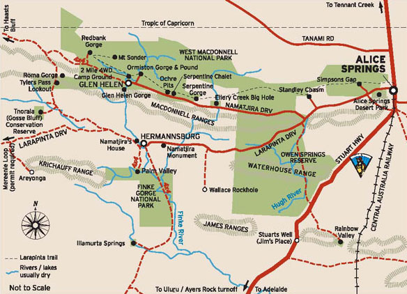
The Trail runs East/West, with one end at an old Telegraph Station just north of Alice Springs and stretching almost 231km (by foot) out along the West MacDonnell Ranges finishing atop Mt Sonder.


The others were heading to Uluru / Ayers Rock first and then winding their way back to Alice via Kings Canyon and West MacDonnell National Park. So I picked a time to fly out to Alice when they should be in the middle of their trip back, camped somewhere along the way. 

To make my trip easier, and save me having to do a bunch of shopping when I landed in Alice Springs, I was able to load up my food drops into plastic tubs and send them on their way in the back of Dads (custom built) camper trailer. Standard affair for hiking food. Dehydrated meals, Muesli Bars, Pasta sides, some dried fruit and Skittles. Lots and lots of skittles. 


The day finally came for my flight out with a lot of my gear already in transit my pack was really light. If only it could be this light all the time! You can check out my loadout here. It's definitely not the lightest kit out there but it's fairly light and I feel it's a good balance between comfort and weight.  

Standard check in affair at the Brisbane domestic airport and a nice relaxing beer in the departure lounge before hopping on my plane. Fairly short flight out and a quick taxi into town. Went to the  hostel to check in, then popped over straight away to the National Parks office to pick up the food drop key and then off to the 'Lone Dingo' camping store to pick up a spare gas can and woolies for final food supplies.

Like a lot of my plans the hike deviated day 0. Jeremy had come into Alice for a restock and refuel and shot me a message. So 2 hours after checking into the hostel I checked out... shortest guest ever? He took me out to Ellery Creek to a surprised Chris and Rod who were expecting to drive into pick me up the next morning. After reading a book to Kristina and Emma and a little communal fire time I was ready for bed. Should be a nice cool night.

Day 1 - 15.8km

Wasn't wrong with it dropping 3°c inside my tent over night. Would have been even colder in the wind... As there was no longer the need to travel into Alice the morning was a lot more relaxed than planned. I sorted out the last little additions for my food boxes and was able to drop the first one right at camp.  

The next two also went in pretty easy. Staff at Standley seemed really friendly and the kiosk at Ormiston proved very useful for their sausage rolls! From there is was a short drive to Redbank Gorge to officially start the hike. 

Kristie and Jeremy came out with the girls to see me off as well as do the walk into the gorge itself. After a few photos we parted ways and I begun setting up base camp.  


A few hikers camped in the river bed but I picked a spot just up the bank. Camp was quickly set and it was time for me to hit up Mt Sonder. Plenty of trail markers dotting the well worn trail kept me on the right track. If it wsnt for the chilling cutting wind it would have been a nice temp too. It was a little cold to hike, but with the uphill slog far to sweaty to don a jacket. Still the entire way up the view got better and better until I was at the top and could take stock of the adventure ahead.  


A lot quicker going down. Bit easier too so I had left my jacket on (which I grabbed as soon as I reached the summit) until about half way down. The wind had miraculously stopped! That was until the moment the jacket sleeve slipped off my wrist, then it hit with another gust. Still I got moving fast and kept relatively warm.

Back at camp I spotted a feral cat licking at drips from the water tank. Second one already, the first on the drive out. Both pretty big. I wandered down to some other hikers, they had just finished. It was nice to get some insight about what's ahead and the good spots. Soon after dinner it was too cold to stay out so I sought shelter in my tent and fell asleep soon after.

Day 2 - 18.7km 

Slow rise again due to the cold morning though at 5° it was warmer than yesterday. I half packed before breakfast and then went for the short wal into Redbank Gorge. The trail along the bank soon went into the river bed with sand underfoot. The closer you got to the gorge the more rocky it became and ended in a beautiful canyon. Water was absolutely freezing. Tinknell would have probably swam though...  


Back to camp to finish packing, said goodbye to the guys I shared dinner with, their bus was due to take them back at 11. Pretty flat trail for most of the day. With the wind still blowing I was hiking in my long sleeve Merino top at a fairly pleasant temp. Felt like leaving the gloves on though. 

Stopped at Rocky bar gap for lunch and to get some water. Not long to camp from here so I stayed for almost 2 hours just enjoying the quiet. Wind was still cold but at least it kept most of the flies away.

Made it to camp just after 2 and picked out one of the pre cleared spots. Plenty to choose from. Not a bad place to wait for a sunset. Had a lot of free time so I explored the top of the hill and extended my rock wall wind break a little. The sun fell just by Mt Sonder and lit the sky with some impressive colours. 


Day 3 - 18.1km 

I new it was going to be colder spending the night at the top of the hill but I wasn't expecting -4°c!! Still I don't think I felt it as bad as the first night at Ellery and it was worth it for the view. Mt Sonder was shrouded in cloud this morning, bit of bad luck for anyone that made the climb for sunrise.  

The day started with a pretty steep downhill slog on loose shale rock, made for slight slower going but provided great views to the south the whole way down. 


When I got to the bottom I reached a section that had been scarred by fire but at almost every burnt out tree were fresh green sprouts springing back to life. There were also a heap of creek crossings including the majestic Finke River. It was a little touch and go there, but I managed to keep my shoes dry.  


The side track into Glen Helen was pretty nice, some great rock formations and some of the water holes on the Finke actually had water! Two Mile camp spot seemed like a good place to stay which I spied from across the pool of water. Glen Helen itself had some awesome burgers and the chips and beer went down pretty smoothly too. 


It was time to hit the trail again only 4.5k to camp for tonight. Making it there by 1330... I think I'll need to do some longer days. The shelter setup was good though, solar to charge batteries/phone, water and a drop toilet. About an hour later a west bound couple hiked in, good to have some company for the night.  


Day 4 - 17.4km  

Pack up was a little easier from the shelter with no tent and seats to use so I was on my way fairly easily. This next section definitely had worse fire scars than yesterday. Without any significant vegetation wind seemed even worse as well. It would have been pushing 40 knots or more as a head wind adding to the strain of hiking. However it was a little warmer than the previous days. 


After about 5k I passed the first hiker going the other way. She was a little surprised when I told her how far it was to the shelter and that I had only been hiking an hour. She had left Ormiston (~4k) over 1.5 hours ago. I got a similar reaction from her friends that I passed soon after. Before 10 I was at the Gorge and grabbed my first drop box to resupply. 

After a nice sit in the sun Rod, Chris, Kristie, Jeremy and the girls showed up so we could hike the pound loop together. Dad was very happy to have my overflow food, skittles and pringles. I think the girls were too. The Pound walk is a really good little loop definitely worth doing if you're out this way. Kristie and Jeremy did an impressive job of carrying the girls (who alone weigh more than my entire pack) in their travel packs. Towards the end I gave Kristie a little break by taking Emma for awhile. 


Back at camp to the kiosk for a nice bacon and egg muffin, plus one for the road. We said our goodbyes, some trail magic (in the form of beer) from Jeremy firmly in hand, and I went off in search of a place to camp for the night. The 'Trail Hiker' section was wall to wall with pre-established big tents, belonging to guided groups, so I shuffled a little further to the coach section where there was a great bunch of guys from Melbourne. 

Nice hot showers here and a chance to wash some clothes, they definitely didn't dry as fast as advertised with my shirt still wet before I went to bed. At camp we shared some good stories about various tracks we've done and future planned ones. Luckily Jeremy gave me 2 beers so I was at least able to share one with them. In return I was offered an amazing pudding snack and even some scotch! Good trade. 

Sadly also in the coach area, not far from us, was a school group. A very loud school group. Kinda wished their leaders took them on a longer hike today because they were still hollering as I was trying to sleep, continuing well past 'hiker midnight' (9pm)

Day 5 - 28.3km  

Quick pack in the morning and said my goodbyes to the Melbourne guys before setting off for a little longer of a day. Wasn't far before a 450m elevation gain, biggest since Sonder. There is an awesome spot that would be perfect for the night about 10k out of Ormiston. Naturally sheltered from the wind and 360 views.  


A little further to the summit with a little '3G is here' sign but I was on a roll so kept moving. Heading down the other side was really steep. SE Ridge on Mt Barney steep. It wasn't long before Waterfall Gorge and lunch. This is where the Melbourne crew were aiming for tonight. With a bit further for me I pushed on.  

Passed a few west bounds, including one lady that had spent the night with the family at Ellery and a pair that were cooking lunch right in the middle of trail. Plenty of spikes grass off trail though so it was a good as place as any. 

I thought I was making great time until I ran into a gully with steep walls and huge boulders to climb over slowing me down. Pretty though. There were also a few wild flowers near trail worth stopping to appreciate.   


Got to the shelter with two other hikers setting up and a lot of day hikers finishing a leg for the day. Excitedly planning the following days activities, lamenting the one kilometre they still had to go to the cars and in awe of my 28+ k day. I spared them (but not you, dear readers) the details of the butt chafing I started to experience at the ~22k mark....  

Shelters are easily big enough for 8 hikers with room to spare. Even 12, 6 per side, would be fine. You'd definitely squeeze in a lot more if you were friends or it was a poor weather night. Still with me at one end the other pair each set up their tents less than 10m away from the shelter. I guess despite the Ormiston shower I probably smell.... in all fairness though, they've done 8 sections so they would too.


Day 6 - 27.9km

Another good start in the morning where the ks fell fast. Wasn't too long before I was at the base of the next big hill. Lots of steps on this climb really making the legs work hard. Wind still hadn't let up either but at least with some switch backs it was a tail wind rather than just a head wind. Counts point was an amazing place to stop for a smoko break.  

(Don't tell mum how close to the edge of the cliff I was to get this shot)


On my way down from the point I met another group of 4 that had shared a fire with the family at Ellery. They were all on the lookout for a orange puffy, but it's a little hard to see packed away. Not many East-bounders though so they took a guess it was me. Lots of people are hiking in their jackets or at least wind blazers. I've set off most mornings with my thermal top on but figure being a little cold on the move is good motivation.

I thought the steps on the way up were bad but down was worse. Little loose rocks/sand making every step a calculated move. Wouldn't want to do this bit with a bung knee. After I was down it was a short jaunt into Serpentine Gorge which was a beautiful spot to stop for lunch.  


For a 'mostly flattish' section the second half of the day certainly had a lot of up and down. Pretty significant rocks to navigate past too. At the top of one such hill was the reward of an old Trig Point. Though might hold more significance to me compared to most other hikers.  


Made it to Ellery Creek just before 4. A day ahead of schedule so far. As always I've slightly over budgeted for food so I was able to leave a few things in the box and label it 'Free Food' so hopefully some other hikers can get some use out of it. There was definitely plenty of food in the storage room though! Might be a busy trail ahead....


Ellery Creek is probably the best waterhole so far as well. Great place for the half way mark. Far to cold for a swim but I managed to hold my feet in there for at least a good 15 seconds... 


Back at camp for dinner and some really friendly campers got a fire going and invited me to share. They didn't have to ask twice! They even offered to take my rubbish after a totally innocent "Did you guys notice any bins on the way in?" Their Trail Magic didn't stop there but I had to decline the 3rd beer as I had a 30k day to look forward to tomorrow. 

Countdown to Alice begins!

Behind the Blogger